


LatLon Convertor app for iPhone and iPad
Developer: 健 李
First release : 17 Dec 2014
App size: 11.91 Mb
the App provides 6 types of the location input method, and 6 types of formats.
The "latitude" (Lat., φ, or phi) of a point on the Earths surface is the angle between the equatorial plane and the straight line that passes through that point and is normal to the surface of a reference ellipsoid which approximates the shape of the Earth. This line passes a few kilometers away from the center of the Earth except at the poles and the equator where it passes through Earths center. Lines joining points of the same latitude trace circles on the surface of the Earth called parallels, as they are parallel to the equator and to each other. The north pole is 90° N; the south pole is 90° S. The 0° parallel of latitude is designated the equator, the fundamental plane of all geographic coordinate systems. The equator divides the globe into Northern and Southern Hemispheres.
The "longitude" (Lon., λ, or lambda) of a point on the Earths surface is the angle east or west from a reference meridian to another meridian that passes through that point. All meridians are halves of great ellipses (often improperly called great circles), which converge at the north and south poles. A line, which was intended to pass through the Royal Observatory, Greenwich (a suburb of London, UK), was chosen as the international zero-longitude reference line, the Prime Meridian. Places to the east are in the eastern hemisphere, and places to the west are in the western hemisphere. The antipodal meridian of Greenwich is both 180°W and 180°E. The zero/zero point is located in the Gulf of Guinea about 625 km south of Tema, Ghana.
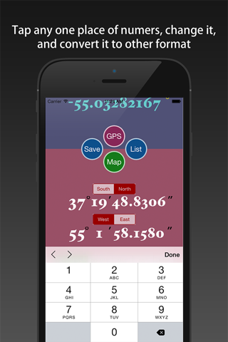
There are many types of the express way for latitude and longitude, the App supports six kinds of common conversion between latitude and longitude format.
You can input a format of latitude and longitude, immediate access to the other five kinds of latitude and longitude. They are:
1) DDD.DDDDD° [degrees]
2) DDD°mm.mmm [degrees - minutes]
3) DDD°mm ss [degrees - minutes - seconds]
4) mm.mmm [minutes]
5) ss.sss" [seconds]
6) radian
[Features]
1) support six common format conversion of latitude and longitude.
2) support using GPS to get the location, and transform.
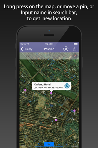
3) support moving the pin on the map to obtain the latitude and longitude of the location, and transform them.
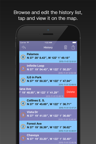
4) support saving the transformation results, and the history records can be viewed, deleted, cleaned up.
5) Every the historical record can be shown on the map, and each of them can be reduced again.
6) You can share one point to others by the Map Interface, and backup all of the history points list by email, the Txt file format, KML file format and PNG file format are both supported. You can open the KML file with Google Earth.
[Location Input Method]
1) shaking your iPhone/iPad.
2) using the keyboard input by hand.
3) using the GPS positioning.
4) moving the pin on the map.
5) long press on the map.
6) search position name on the map view.